
Caspian Sea - The largest closed reservoir in the world
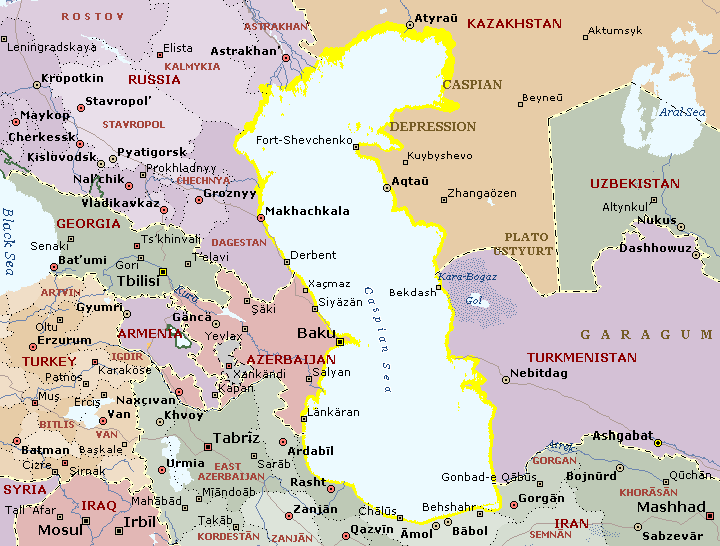
Caspian Sea washes the western part of Kazakhstan. The name of the Sea is connected with the Caspii tribes who had settled shores from time immemorial. It had had such names as Girkanskoye, Khazarskoye, Khvalynskoye. The first mentions about Caspian Sea and its tribes were in the works of Gerodot. The document about the Russian navigators’ visit of Caspian Sea and theirs boating is dated back to IX-X centuries. At the beginning of XVIII century Peter-I had begun the constant research of the Caspian Sea (expeditions of Bekovich-Cherkasky A. and others). Then Soimonov I.F., Ivashinsev N.A., Pallas P.S., Gmelin S.G., Karelin G.S., and others researched the Caspian Sea.
The Caspian Sea is stretched from north to south to 1200km; the medium width is 320km, the length of the shore line is about 7000km (6000km of which in the territory of Russia and other countries). The area of waterland is 371000sqkm; the sea level is lower than ocean’s level to 28,5 (1971). The max depth is 1025m (in the southern part); the Kazakhstan part is not deep, the depth of the north Caspii is about 15-20m. The largest gulfs are: Komsomolets, Mangyshlaksky (Magystau), Kenderli, Kazakhsky, Kara-Bogas-Gol, etc. The total territory of the 50 islands is about 350sqkm. The rivers Volga, Ural and Emba flow into the Caspian Sea from the north side. By the bottom relief and hydrological features we can distinguish the Northern, the Middle and the Southern Caspii.
At the bottom of the Caspian Sea there are deposits of oil and gas.
The Caspian Sea crosses some climate zones: in the northern part - the continental, on the western – the temperate-warm, in the south-western – wet-subtropical, on the east – dry-steppe zone. The northern part differentiates by the sudden changeability of the air temperature and insufficiency of atmospheric precipitation. In the northern and middle parts in October-April the wind blows from the east, in May-September the monsoon wind blows from the north-western part to the south, on the eastern middle parts, in the north-western and north parts there are such winds the speed of which exceeds 24m/s. Average temperature of July and August is +24+26’C, the absolute maximum is +44’C on the east. In winter months the temperature changes from –10’C in the north and to –12’C in the south. About 200mm of atmospheric precipitation fall over the Sea. Average value of evaporation is 1000mm per year. Average temperature of the water surface is +24+26’C in summer, in the southern part is +29’C. Average temperature of the water in the north is –0,5’C in winter, in the middle part from –3’C to –7’C, and in the south –8-10’C. In the north the water surface freezes from November to March, the ice is 2m thick. Average water salty is 12,7-12,8%, on the eastern coast is 13,2%, in the closest parts of Volga and Ural mouth is 0,1-0,2%. The sea level sometimes rises to 2-2,5m and falls to 2m. The total season fluctuation is about 30cm. It is known, that the lowest sea level was in VII-XI centuries (to 2-4m lower than nowadays). The last falling of the sea level continued from 1929 to 1057. The falling of the sea level is the result of dry climate, and the building of the largest hydrotechnic and irrigation buildings on the river. Flora and fauna of the Caspian Sea are comparatively poor. More than 500 kinds of plants, 854 kinds of fishes and animals, some kinds of aquatic birds dwell here. There are large populated areas near the Caspian Sea such as: Guriev, Shevchenko, Eraliev, Balykshy, Ganushkino, etc and important economic regions.