


Haft Kul in the Fann Mountains
In western Tajikistan, near Penjikent, seven mountain lakes stretch through the narrow Shing River gorge in the Fann Mountains. Known collectively as Haft Kul, meaning “Seven Lakes” in Tajik, they are also sometimes called the Marguzor Lakes after the largest lake in the group.
From lowest to highest, the seven lakes are Nezhigon, Soya, Gushor, Nofin, Khurdak, Marguzor and Hazorchashma. Their colours shift with the light, weather and season, ranging from deep blue and turquoise to green and violet.
The first lake lies at around 1,640 m above sea level, while the seventh is at around 2,400 m. Most of the lakes were formed when rockfalls and landslides created natural dams across the narrow gorge. Hazorchashma, the highest lake, has a different origin and is fed by numerous springs and mountain streams.
Ancient petroglyphs found near Marguzor point to a long history of human presence in the valley.
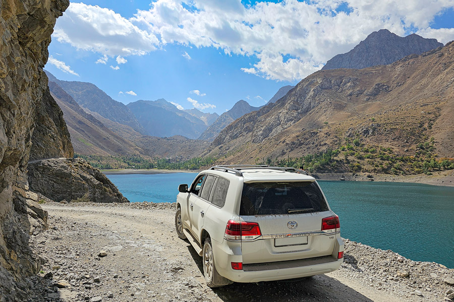
A mountain road connects the lakes and passes through several small villages. The lower sections are relatively straightforward, but the route becomes considerably rougher higher in the valley. Beyond Nofin, the fourth lake, some stretches are unpaved, steep and bumpy, and conditions can vary with the weather and water level. Travellers who are sensitive to rough roads or prone to motion sickness should be prepared for an uncomfortable ride on the upper sections.
Although the lakes can be visited by road, walking is one of the best ways to experience the valley. Short hikes are possible between individual lakes, while longer routes continue into the surrounding valleys and higher parts of the Fann Mountains.
Several villages, particularly around Nofin, have simple guest houses and homestays. Facilities are generally more basic than in Tajikistan’s larger cities, so travellers staying overnight should expect modest accommodation. Camping is also possible at a number of places along the river and near the lakes.
Water levels vary through the year. The lakes are fed by mountain streams and usually reach their highest levels in summer; at other times of year, the shorelines and some sections of the road may look quite different.
Nezhigon

Nezhigon, the first and lowest of the Seven Lakes, lies at around 1,640 m above sea level.
The lake is also known by several variations of its name, including Nezhegon, Nezhigok and Mizhgon. Its name is commonly associated with the Tajik word for “eyelash”, although the exact origin is uncertain.
Nezhigon is particularly striking for the changing colour of its water. Depending on the season, weather and angle of the light, the lake can appear turquoise, deep blue or even violet. Its changing colours are influenced by the light, weather and mineral content of the water.
Soya

The road climbs from Nezhigon towards Soya, the second of the Seven Lakes. Looking back from this section also gives a good view over Nezhigon below.
Soya means “shadow” in Tajik, an appropriate name for a lake enclosed by high cliffs and shaded for much of the day.
Like Nezhigon, the colour of its water changes with the weather and light. The lake lies at around 1,700 m above sea level.
Gushor

Only a short distance separates Soya from Gushor, the third lake. Between them, the water funnels through the narrow gorge in a fast mountain current.
Gushor lies at around 1,770 m above sea level. Alternative spellings include Khusher and Ishore.
The name is generally associated with the idea of being “watchful” or “vigilant”, although local stories give different explanations for its origin.
During the Soviet period, a campsite stood near Gushor but was later destroyed by a landslide. Today, little remains of it, and the lake is surrounded mainly by steep mountain slopes and clear water in which small fish can sometimes be seen close to the shore.
Nofin

The fourth lake, Nofin, begins only a short distance beyond Gushor.
Nofin is long and narrow, stretching through the valley like a ribbon at around 1,820 m above sea level. Its name is commonly translated as “umbilical cord”, traditionally associated with the lake’s elongated shape.
The road follows Nofin’s eastern shore. Water levels can affect some sections in summer, occasionally making passage more difficult.
A small village at the far end of the lake has locally run guest houses, making Nofin one of the more practical places to stay overnight in the valley.
Khurdak

Khurdak, the fifth lake, is the smallest of the Seven Lakes. Its name is associated with a Tajik word meaning “small” or “little”, fitting its modest size.
The lake lies at around 1,870 m above sea level.
Between Nofin and Khurdak is the village of Padrut, one of several small settlements in the Shing Valley. A micro-hydropower station here once supplied electricity to Padrut and neighbouring communities.
Marguzor

Marguzor, the sixth lake, is the largest of the Seven Lakes and one of the most impressive points on the route. It lies at around 2,140 m above sea level.
Its broad blue-green surface is framed by steep, largely treeless mountains, giving Marguzor a more open appearance than some of the lower lakes.
Petroglyphs have been discovered near its shores, while historical sources also refer to the mining of semiprecious stones in the surrounding area during the Middle Ages.
A small village stands on the southern shore.
The road follows the eastern side of Marguzor and in places runs very close to the water. High water levels can make some sections difficult to pass, particularly for ordinary vehicles.
A trail towards the Tavasang Pass, at approximately 3,307 m, begins near the southern end of Marguzor and continues into the Fann Mountains.
Hazorchashma

At around 2,400 m above sea level, Hazorchashma is the highest of the Seven Lakes.
Its name comes from the Tajik words hazor, meaning “thousand”, and chashma, meaning “spring”, a reference to the numerous springs and mountain streams that feed the lake.
Hazorchashma marks the end of the road through the Seven Lakes. Beyond it, there are no permanent settlements, and travel continues on foot into the higher Fann Mountains.
The final approach is the roughest section of the route, and depending on road conditions, part of it may need to be completed on foot.
Most visitors see Hazorchashma from its northern shore, where the road ends. Those who walk further around the lake or climb above it can gain wider views across the water and back down the valley towards Marguzor.
How to Get to the Seven Lakes
The Seven Lakes are reached by road from Penjikent. From the city, the route initially follows the main road towards Dushanbe before turning south into the Shing Valley. The paved road eventually gives way to an unpaved mountain road as it approaches the lakes.
The journey to the lower lakes takes around an hour in good conditions, but travelling through the complete chain takes considerably longer once stops are included.
Road conditions become progressively rougher higher in the valley. Beyond Nofin, some sections are steep, unpaved and uneven, so a suitable vehicle is important for reaching the upper lakes. Conditions can also change with the weather and water level.
Travellers prone to motion sickness should be prepared for a bumpy ride.
The Seven Lakes can also be visited from Samarkand, Uzbekistan, via the Jartepa–Sarazm border crossing. Although the distance is relatively short, the international border crossing and change of transport add time to the journey.
It is best to allow at least a full day for a visit from Penjikent or Samarkand. Even a relatively quick trip involves stops at several lakes, while reaching the upper part of the valley takes additional time.
Travellers with more time can stay overnight in a local guest house and explore some of the valley on foot. This makes it possible to spend longer around the upper lakes and experience the area beyond the main roadside viewpoints.
For those who prefer an organised visit, Seven Lakes tours include day trips from Samarkand and longer itineraries via Penjikent.