
 For the first time the name of Tashkent appeared in works of the scientist Abu Raykhon al-Beruni and in works of Makhmud Kashgariy in the 11th century. Since the 13th century the name of Tashkent appeared in all official documents and coins.
The economic decay of the Tashkent oasis in the 12th century was promoted by the depletion of Ilak silver and lead mines, which were the base of rapid origin and development of many cities of Shash-Ilak region. It caused to reduction of Shash power and cleared the ground for the invasion of Genghis Khan in the beginning of the 13th century. In the early 13th century Tashkent twice suffered from damages. In the beginning the last Khoresm ruler Mukhammad, joined the Tashkent oasis and Ferghana and during the struggle against khan of nomad Nayman tribes of Kuchluk ordered to destroy the irrigation system and to remove its inhabitants. The second destruction of Tashkent occurred during the invasion of Genghis Khan. The whole Shash oasis was ruined as well as other regions of Central Asia. In the end of 13th century the city was reconstructed. In the 14th century during the reign of Amir Temur and Temurides Tashkent gained the importance of an advanced post on the junction of oasis with nomadic steppe.
In the 14th century the city consisted of the citadel enclosed with a wall and gates and Shakhristan. By legend, the gates were named after uluses, tribes and families, members of which protected them. Memorial complexes of Khazrat-Imam and Zaynaddin Kui Arifoni (Furkat street) were formed and developed beyond the city. At that time necropolises such as Khast-Imam and Sheykhantaur were founded. Borders of the city were rather extended as opposed to 10th-13th centuries.
There are no buildings of Tamerlane’s and Ulugbek’s epochs in Tashkent. The only exclusion was the Zangi-ota mausoleum, by legend regarded to Temur, located to the south from the center of the city. Some buildings of 15th century were connected with Khoja Akhror, the eminent spiritual leader of Mavarannahr. These were two-storey madrassah and Jami mosque, which did not reach our days. According to a legend, he erected several mosques and madrassas in the city.
The city experienced the flourishing in the 16th century. During this period, the dynasty of Sheibanids came to power and Tashkent removed to the possession of Suyunij-Khoja, the representative of the northern branch of Sheibanids’ dynasty. Each of the governors built madrassahs, mosques and mausoleums in terms of the state of treasury and to the extent of talent of court architects. The area of Tashkent in the 16th century was the same size as in the previous century. Written sources mentioned Samarkand Gate, Kukcha Gate, Parkent Gate, Shavli Gate, and in the end of the century Registan Gate too. During that period, landscape art developed in Tashkent. For example the garden of Tashkent rulers of Keykaus (kind of Chorbag). The garden of Keykaus was the place of medjlises, meetings as in the courts of the Samarkand and Herat rulers. The garden was located in the northwest part of the city. Mahalla and Tepe of Hiaban (literally "Alley") reached our days.
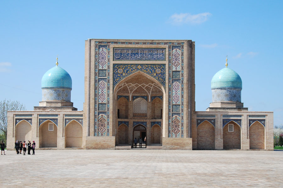
 In 60s of the 16th century the Kukeldash Madrassah was built. It completed the ensemble on the Chorsu square, which was the centre of city life of that time. The Chorsu bazaar was not only the site of bargains but also the center of the entire public life. It was a peculiar town, which included specialized craft and trade streets, caravanserais for merchants, bathhouses, tearooms (choihona), oshhonas, bakeries and mosques. Tashkent was rapidly built-up. Madrassahs, mosques, maktabs and bathhouses appeared everywhere. Architecture of houses and mosques was interesting and various with rich and fancy decoration. Architectural complex of Khast-Imam (Barak-khan Madrassah and Kafal-Shashi mausoleum) was founded in the northern part of the city. On the territory of former citadel (14th century) researchers discovered a bathhouse of the 16th century. The major part of architectural monuments of that period reached our days.
In the end of 16th century Tashkent rulers constantly participated in feudal wrangles for leadership, which boiled in possessions of Shaibanids. Tashkent repeatedly was under siege. Abdulla-khan carried on the persistent struggle for the consolidation of the state of Sheibanids, however rulers of the city maintained the resistance to him.
The end of 16th century was the period of the end of the dynasty of Sheibanids and the most troublesome time in the life of Tashkent. Struggle of Kazakhs, Kyrgyzes, Bukhara and Kokand rulers for the power over Tashkent in 17th-18th centuries caused to the destruction of the city. Caravan trade was almost terminated, as caravans were robbed due to the anarchy. The irrigation system fell to decay and rushy wetlands appeared even in the city. According to legends rush brushes came close to the hill of shakhristan, especially from western and southwestern sides. Agriculture and trade fell to decay and the city suffered from the heavy crisis. Even a semblance of centralized government disappeared and in the 18th century the city broke up into four parts (daha): Sheikhantaur, Beshagach, Kukcha and Sebzar. Each daha was independently governed by a hakim. They struggled for superior power. And the whole city represented four opposing military camps.
In the end of the 18th century four Tashkent hakims struggled against each other. It came to an open arm conflict, and the battle occurred in the ravine near city bazaar, known as Jangob – “the stream of battle”. Yunus-Khoja, the head of Sheikhantaur daha won the battle. During his reign he settled Tashkent economy, adjusted safe caravan route. Copper and iron industry were developed, areas of gardens and fields were increased, the city was strengthened.
The city was still divided into four dahas. Each of them had three gates in the city wall. So Sibzar daha had Labzak, Tahtapul and Karasaray, Kukcha daha - Sagban, Chagatai and Kukcha, Beshagach daha – Samarkand, Kamolon and Beshagach, Sheikhantaur daha -Koymas, Kashgar, and Kokand. Yunus-Khoja built Urda in Beshagach daha, the ruins of which survived until the end of 19th century. After death of Yunus-Khoja the Kokand khan applied all efforts to submit Tashkent.
Urda was the fortress, built by Kokand people after the conquest of Tashkent. In 1809 Tashkent with city walls and gates occupied the territory of about 1600 hectares. Beshagach, Koymass and Kokand gates were located on the left bank of Boz-Su, because one part of city walls stretched on the left bank of it. Kokand strategists erected Urda exactly on the high bank of Bozsu, because it had a good panorama of the city from the walls of the fortress that gave an opportunity to fire any part of the city. The fortress was intended not only to protect the city against invasions but also to keep in submission rebellious people of Tashkent. The fortress was protected against a storm from the city with a water barrier, the Anchor channel. Also the fortress could receive the Kokand reinforcement from southeast, if any.
The analysis of the Urda project and original sources allow stating that the Kokand Urda was built according to the model of Central Asian fortresses, formed in Middle Ages and reached to the 19th century almost unchanged. Urda occupied the territory of about 20 hectares. The walls of northern, eastern and southern directions were straight and later designated directions of modern streets of Sh. Rashidov, A.Kadyri, A.Navoi, and western wall coincided with the direction of the Anchor channel. Mud walls of Urda were up to 6 meters wide in foundation and 10-14 meters high. The 4-meter wide top ground had a parapet with outside loopholes, and inner side was open. Special attention was paid to the fortification of northern part, where the bastion with three towers was established.
Urda consisted of ammunition depots and garrison. Retinues of Kokand deputy, Beklarbek with suite and servants were accommodated there. Some part of military men and their families were accommodated in the northern part of the fortress. The palace of Kokand Beklarbek and services were placed near the main bastion. About 50 houses were placed among gardens and vineyards on the whole territory. Water supply was carried out by full water aryk of Gadragan, flowing through the fortress. From the eastern part Urda bordered with the Sarbaz courtyard with the area of 27 hectares, stretching beyond Chauli. Private and military men lived there in tents and barracks. Enclosed with walls and moats the Sarbaz courtyard also had three gates: one gate was connected with Urda, other gate (Kashgar) led to the east, to Shakrisabz street, and third one, Kokand Gate, located on the right bank of Chauli aryk and was directed to the south. In the case of drainage of channels, which was frequently practiced by enemy at the siege, inhabitants dug the reservoirs (khauzes).
Under the Kokand domination Tashkent had a weak political position, because the Kokand and Bukhara Khanates carried out the resistant struggle for Tashkent lands. The power of Kokand Khanate over Tashkent finished after the conquest of Central Asia by Tsarist Russia. Frozen in development architecture of Central Asia continued to exist close to spread European architecture after joining to Russia.
Appearance of Russian population changed the life of Tashkent, all the more that it was the appearance not of separate Russian towns, but Russian districts in ancient towns. Such situation was in Tashkent. Military and administrative center moved to the east at that time. On February 12, 1865 the decree on formation of Turkestan region with submission to the Orenburg General Government was issued. The General Chernyaev was appointed the Military Governor of reformed region. The detached force under his leadership seized Tashkent in June of 1865. In 1866 the city was officially included in the Russian possesions. Tashkent was rapidly advanced as the main center of trade relations between Russia and Central Asian khanates and neigboring countries. It was decided to build new city close to old one, on the left bank of the Anchor channel. The territory from the Anchor channel to Chauli aryk was planned by rectangular scheme. Next spring new General Governor Romanovskiy chosed the place for immediate building of European city.
In 1866 the Russian fortress with thick wall was built on the high bank of the Anchor channel, on the border of new and old cities. Beyond fortress bank there were baracks for military men.
The Turkestan General Governship in the Russian Empire was established in 1867. Fon Kaufman became the first General Governor of it.